Home About KGC GPaaS Members Events Training Contact Us
     
  GPaaS - GIS Professionals as a Service  


We all are quite familiar with the term “cloud computing” which is a rapidly emerging technology. Although there are several variations on the definition of cloud computing, but the terms SaaS, PaaS and IaaS are quite popular these days. We are coming up with a new concept called GPaaS or Geospatial Professional as a Service which mean Geospatial Professionals delivered as a service online rather than as traditional, on-premises consultancy services. The fast pace of today’s business requires more flexibility and the ability to provide services at anytime from anywhere to anywhere in the world. Our innovative idea of GPaaS enabled us to provide the end users with services which will be accessible via the internet and any one can log into our website (keralagiscommunity.com\GPaaS) and request for a service. 

GPaaS offerings can range from geospatial consultancy services to spatial data porting to other focused end-user Web applications.
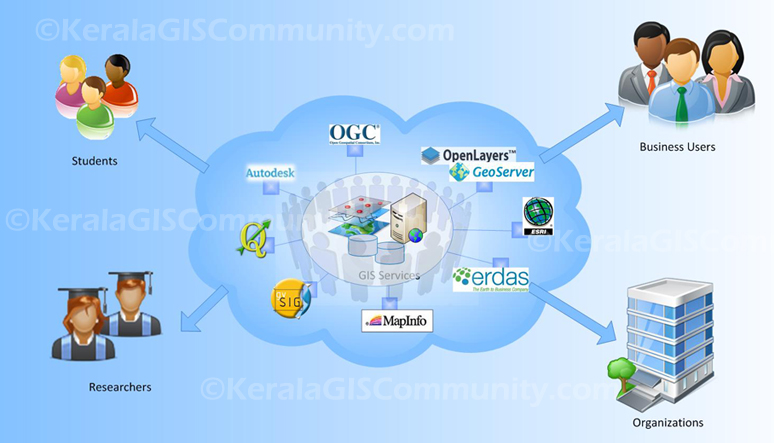
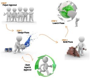


GPaas


With GPaaS You Get…

  • Consultation on any geospatial Technologies
  • Consultation on GIS Application / Website Development
  • Consultation on Geodatabase design and development
  • Geospatial Training activities
  • Consultation on spatial data porting/generation

How it works…
Our goal is to keep things simple…

Let's talk about how the concept of GPaaS works and how we can help you in reaching your geospatial objectives or how the process flows, say from quote to launch...
Once you submit the online support request, we consult with you to define your objectives, learn about your requirements or expectations to understand your hopes.
Our GPaaS consultants will do a research on your expectations and will come up with an detailed sketch explaining how we can approach the mission , what we can do and what you should do. We will also evaluate the available spatial datasets to build your solution and provide you the details regarding them...
Once you get convinced with the plan we utilize that information to get you a customized quote so you know exactly what you're paying for (no hidden fees), we usually charge a nominal fees for the hourly services of our GPaaS consultants which you can track online in our project management system.

Once we both agree to go forward, we will create an online project and provide you with the logging credentials where we capture all the activities of the engagement. We also provide you a login to access a secured online data storage through which we can share the contents related to the project.

Our team will create mock ups and share that stuff through this portal. We will arrange review for the mock-up with you to find out what you like, and what you want changed (most review sessions are conducted via online meetings).

Our team updates the mock-up according to your feedback. We work through additional reviews and revisions with you as required, all tracked through our Project Management tool. Once you approve your mock-up, we build a functional application and share it with you, make any additional finishing touches if required.

The last step is launching your project and we will help you in deploying the application in your premises using remote access softwares and all the project stuff will be shared through the portal. In rare cases we can provide on-site support as well.

Never worry about the turnaround times during the project timelines and we promise you very quick response within the same business day.
If you want to obtain more details about GPaaS, please contact us via our GPaaS request  form, and we will be happy to help you out.  Also, if you don't feel comfortable ordering directly online, then you can also contact us through email and a real person will be happy to follow-up with you.

In effect we follow the principle of cloud computing which furnishes technological capabilities—commonly maintained off premises—that are delivered on demand as services via the Internet.


© All rights reserved Kerala GIS Community